From Pixels to Precision

SatSure Super Resolution

Download Whitepaper

Cost Efficiency

Cost
Efficiency

More than 75% cost reduction compared to commercially available medium-resolution optical satellite imagery.
Versatile Applicability

Versatile
Applicability

Diverse applications across a spectrum of sectors, including agriculture, forestry, environmental monitoring, etc.
Enhanced Analytical Precision

Analytical Precision

The enhanced spatial, structural & perceptual resolution enables better crop classification, object identification & insights generation.
High Accuracy

High
Accuracy

SatSure Super Resolution algorithm ingests multi-image temporal data to deliver high-accuracy data.

4x the Clarity, 4x the insights

SatSure Super Resolution is a groundbreaking Technology that enhances the spatial resolution of Sentinel-2 imagery by fourfold, transforming it from 10-meter to 2.5-meter while preserving structural, perceptual, and spectral characteristics. Compared to commercially available high-resolution optical satellite imagery with similar spatial resolution, SatSure’s super-resolved imagery is highly cost-effective and analytics-ready.

Be a part of this revolutionary technology and witness first-hand the potential of SatSure Super Resolution with our comprehensive whitepaper packed with detailed insights on the technology and lets you understand the broader picture of the super resolution and its various applications.

Download Whitepaper

A Journey Beyond Pixelated Limitations to Fine-detailed Insights

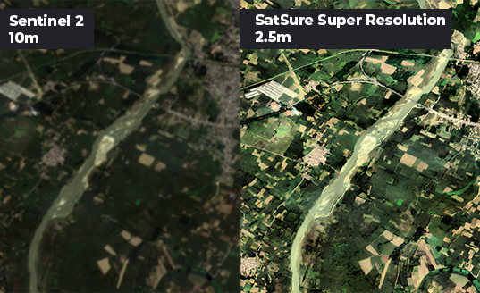
Experience the future of insights generation – where every pixel tells a story, and every decision is backed by clarity and accuracy with SatSure Super Resolution.

SatSure Super Resolution algorithm breathes new life by eliminating the need for expensive high-resolution satellite imagery. The boundless applications expand into key sectors of agriculture, forestry, environmental monitoring, urban planning, disaster management, scientific research, and beyond.

Download Whitepaper

Decision
intelligence
from space.

Decision intelligence from space.